Nouméa
Nouméa | ||
|---|---|---|
Commune | ||
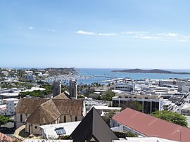 City centre and Nouméa Cathedral | ||
| ||
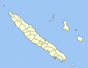 Location of the commune (in red) within New Caledonia | ||
Location of Nouméa | ||
| Coordinates: 22°16′33″S 166°27′29″E / 22.2758°S 166.4580°E / -22.2758; 166.4580Coordinates: 22°16′33″S 166°27′29″E / 22.2758°S 166.4580°E / -22.2758; 166.4580 | ||
| Country | France | |
Sui generis collectivity | New Caledonia | |
| Province | South Province (provincial seat) | |
| Government | ||
| • Mayor .mw-parser-output .nobold{font-weight:normal} (2014–present) | Sonia Lagarde | |
| Area 1[1] | 45.7 km2 (17.6 sq mi) | |
| • Urban | 1,643 km2 (634 sq mi) | |
| Population (Aug 2014 census[2])2 | 99,926 | |
| • Density | 2,200/km2 (5,700/sq mi) | |
| • Urban | 179,509 | |
| • Urban density | 110/km2 (280/sq mi) | |
| Ethnic distribution | ||
| • 1996 census | Whites 50.9% Kanaks 22.9% Polynesians 12.3% Other 13.9% | |
INSEE/Postal code | 98818 /98800 | |
| Elevation | 0–167 m (0–548 ft) (avg. 20 m or 66 ft) | |
1 New Caledonia Land Register (DITTT) data, which exclude lakes and ponds larger than 1 km² (0.386 sq mi or 247 acres) as well as the estuaries of rivers. 2Population without double counting: residents of multiple communes (e.g., students and military personnel) only counted once. | ||


Nouméa city flag
Nouméa (French pronunciation: [nume.a]) is the capital and largest city of the French special collectivity of New Caledonia. It is situated on a peninsula in the south of New Caledonia's main island, Grande Terre, and is home to the majority of the island's European, Polynesian (Wallisians, Futunians, Tahitians), Indonesian, and Vietnamese populations, as well as many Melanesians, Ni-Vanuatu and Kanaks who work in one of the South Pacific's most industrialised cities. The city lies on a protected deepwater harbour that serves as the chief port for New Caledonia.
At the August 2014 census, there were 179,509 inhabitants in the metropolitan area of Greater Nouméa (French: agglomération du Grand Nouméa), 99,926 of whom lived in the city (commune) of Nouméa proper.[2] 66.8% of the population of New Caledonia live in Greater Nouméa, which covers the communes of Nouméa, Le Mont-Dore, Dumbéa and Païta.
Contents
1 History
2 Geography
3 Demographics
3.1 Historical population
3.2 Migrations
3.3 Ethnic communities
3.4 Languages
4 Climate
5 Economy
6 Transport
7 Education
8 Twin towns – sister cities
9 Popular culture
10 References
11 External links
History
The first European to establish a settlement in the vicinity was British trader James Paddon in 1851. Anxious to assert control of the island, the French established a settlement nearby three years later in 1854, moving from Balade in the north of the island. This settlement was initially called Port-de-France and was renamed Nouméa in 1866. The area served first as a penal colony, later as a centre for the exportation of the nickel and gold that was mined nearby.
From 1904 to 1940 Nouméa was linked to Dumbéa and Païta by the Nouméa-Païta railway, the only railway line that ever existed in New Caledonia.
During World War II, Nouméa served as the headquarters of the United States military in the South Pacific. The five-sided U.S. military headquarters complex was adopted after the war as the base for a new regional intergovernmental development organisation: the South Pacific Commission, later known as the Secretariat of the Pacific Community.
The city maintains much of New Caledonia's unique mix of French and old Melanesian culture. Even today the US wartime military influence lingers, both with the warmth that many New Caledonian people feel towards the United States after experiencing the relative friendliness of American soldiers and also with the names of several of the quarters in Nouméa. Districts such as "Receiving" and "Robinson", or even "Motor Pool", strike the anglophone ear strangely, until the historical context becomes clear.
Geography
The city is situated on an irregular, hilly peninsula near the southeast end of New Caledonia, which is in the south-west Pacific Ocean.[citation needed]
Neighbourhoods of Nouméa include:[3]
- Rivière-Salée
- 6e km, 7e km, Normandie, and Tina
- Ducos peninsula:
- Ducos, Ducos industriel, Kaméré, Koumourou, Logicoop, Numbo, Tindu
- 4e Km, Aérodrome, Haut Magenta, Magenta, Ouémo, and Portes de fer
- Faubourg Blanchot and Vallée des Colons
- Doniambo, Montagne coupée, Montravel, and Vallée du tir
- Artillerie Nord, Centre Ville, Nouville, Quartier Latin, Vallée du Génie
- Anse Vata, Artillerie Sud, Baie des Citrons, Motor Pool, N'géa, Orphelinat, Receiving, Trianon, and Val Plaisance
Demographics

A woman at a market in Nouméa
The Greater Nouméa urban area (French: agglomération du Grand Nouméa) had a total population of 179,509 inhabitants at the August 2014 census, 99,926 of whom lived in the commune of Nouméa proper.[2]
The Greater Nouméa urban area is made up of four communes:
- Nouméa (99,926 inh.)
Dumbéa (31,812 inh.), to the north-west of Nouméa
Le Mont-Dore (27,155 inh.), to the north-east of Nouméa
Païta (20,616 inh.), a suburb to the west of Dumbéa and the site of La Tontouta International Airport
Historical population
| 1956 | 1963 | 1969 | 1976 | 1983 | 1989 | 1996 | 2009 | 2014 | ||||
|---|---|---|---|---|---|---|---|---|---|---|---|---|
| Nouméa (commune) | 22,235 | 34,990 | 41,853 | 56,078 | 60,112 | 65,110 | 76,293 | 97,579 | 99,926 | |||
| Greater Nouméa | 25,204 | 39,996 | 50,488 | 74,335 | 85,098 | 97,581 | 118,823 | 163,723 | 179,509 | |||
Official figures from population censuses.[2][4] | ||||||||||||
Average population growth of the Greater Nouméa urban area:
- 1956-1963: +2,310 people per year (+7.5% per year)
- 1963-1969: +1,791 people per year (+4.1% per year)
- 1969-1976: +3,349 people per year (+5.6% per year)
- 1976-1983: +1,543 people per year (+2.0% per year)
- 1983-1989: +2,091 people per year (+2.3% per year)
- 1989-1996: +3,020 people per year (+2.8% per year)
- 1996-2009: +3,382 people per year (+2.4% per year)
- 2009-2014: +3,106 people per year (+1.8% per year)
Migrations
The places of birth of the 179,509 residents in the Greater Nouméa urban area at the 2014 census were the following:[5]
- 66.7% were born in New Caledonia
- 21.2% in Metropolitan France and its overseas departments (other than Wallis-and-Futuna and French Polynesia)
- 6.3% in foreign countries (notably Indonesia, Vanuatu, Vietnam, and Algeria)
- 5.8% in Wallis and Futuna (essentially) and French Polynesia (to a lesser extent)
Ethnic communities
The self-reported ethnic communities of the 179,509 residents in the Greater Nouméa urban area at the 2014 census were as follows:[5]
- 34.5% Europeans
- 23.4% Kanaks (original Melanesian inhabitants of New Caledonia)
- 11.5% Wallisians and Futunians
- 10.0% mixed ethnicity
- 20.5% other communities (this group includes in particular the White people of New Caledonia who refused to self-identify as "Europeans")
Languages
At the 2009 census, 98.7% of the population in the Greater Nouméa urban area whose age was 15 years old and older reported that they could speak French. 97.1% reported that they could also read and write it. Only 1.3% of the population whose age was 15 years old and older had no knowledge of French.[6]
At the same census, 20.8% of the population in the Greater Nouméa urban area whose age was 15 years old and older reported that they could speak at least one of the Kanak languages. 4.3% reported that they could understand a Kanak language but not speak it. 74.9% of the population whose age was 15 years old and older had no knowledge of any Kanak language.[7]
Climate
Nouméa features a tropical wet and dry climate with hot summers and warm winters. Temperatures are warmer in the months of January, February and March with average highs hovering around 30 degrees Celsius and cooler during the months of July and August where average high temperatures are around 23 degrees Celsius. The capital’s dry season months are September and October. The rest of the year is noticeably wetter. Nouméa on average receives roughly 1,100 mm (43 in) of precipitation annually.
| Climate data for Noumea, New Caledonia | |||||||||||||
|---|---|---|---|---|---|---|---|---|---|---|---|---|---|
| Month | Jan | Feb | Mar | Apr | May | Jun | Jul | Aug | Sep | Oct | Nov | Dec | Year |
| Average high °C (°F) | 28.9 (84) | 29.0 (84.2) | 28.5 (83.3) | 26.9 (80.4) | 25.2 (77.4) | 23.8 (74.8) | 22.6 (72.7) | 22.8 (73) | 23.8 (74.8) | 25.5 (77.9) | 27.0 (80.6) | 28.2 (82.8) | 26 (78.8) |
| Daily mean °C (°F) | 26.0 (78.8) | 26.1 (79) | 25.6 (78.1) | 24.1 (75.4) | 22.5 (72.5) | 21.1 (70) | 20.0 (68) | 20.5 (68.9) | 21.1 (70) | 22.4 (72.3) | 23.9 (75) | 25.0 (77) | 23.2 (73.7) |
| Average low °C (°F) | 23.0 (73.4) | 23.2 (73.8) | 22.8 (73) | 21.4 (70.5) | 19.8 (67.6) | 18.5 (65.3) | 17.3 (63.1) | 17.5 (63.5) | 17.9 (64.2) | 19.2 (66.6) | 20.7 (69.3) | 21.9 (71.4) | 20.3 (68.5) |
| Average precipitation mm (inches) | 112.9 (4.44) | 123.1 (4.85) | 134.6 (5.3) | 110.5 (4.35) | 90.6 (3.57) | 128.7 (5.07) | 73.0 (2.87) | 70.1 (2.76) | 39.2 (1.54) | 53.2 (2.09) | 62.9 (2.48) | 72.7 (2.86) | 1,071.5 (42.18) |
| Average precipitation days | 14.2 | 14.2 | 17.1 | 15.0 | 16.8 | 17.3 | 15.9 | 13.1 | 9.6 | 9.3 | 10.3 | 11.3 | 164.1 |
| Mean monthly sunshine hours | 232.5 | 209.0 | 201.5 | 198.0 | 176.7 | 156.0 | 182.9 | 201.5 | 222.0 | 251.1 | 249.0 | 260.4 | 2,540.6 |
| Source: Hong Kong Observatory,[8] | |||||||||||||
Economy
Although Nouméa has more sunshine days than any other Pacific Island capital and beaches not far from the city centre, it is not currently a major tourist destination. The cost of living is high and air travel is not discounted to the same extent as to other destinations on the Pacific Rim.[citation needed]
Nouméa is, as of 2007[update], one of the most rapidly growing cities in the Pacific and has experienced a major housing construction boom in the preceding decade. The installation of amenities has kept pace and the municipality boasts a public works programme. Much of this construction is fuelled by investment from France and it is hoped that over the lifetime of this multi-decade track towards increased autonomy planned under the Matignon Agreements and now the Nouméa Accord, the local economy will become independently sustainable.[citation needed]
Transport
Aircalin, the international airline of New Caledonia,[9] and Air Calédonie (Aircal), the domestic airline, have their headquarters in the city.[10] Aircal's headquarters are on the grounds of Nouméa Magenta Airport,[11]
which serves local routes. Nouméa's international airport is La Tontouta International Airport, 50 kilometres (31 mi) from the city.
The Nouméa-Païta railway, which was the only railway line that ever existed in New Caledonia, was closed in 1940.
Education
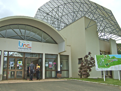
University of New Caledonia, Nouville campus

Bernheim Library exterior

Bernheim Library interior
The University of New Caledonia (UNC) goes back to 1987 when the Université Française du Pacifique (French University of the Pacific) was created, with two centres, one in French Polynesia and the other in New Caledonia. In 1997 the decision was made to split the two parts into separate universities and so in 1999 the Université de la Nouvelle Calédonie and the Université de la Polynésie Française were formed.
UNC welcomes around 3,000 local and international students and 100 professors and researchers each year.[12]
The Bibliothèque Bernheim (Bernheim Library) is located in Nouméa.[13]
Twin towns – sister cities
 Gold Coast (Australia)
 Nice (Metropolitan France)[14]
 Taupo (New Zealand)
Popular culture
- New Caledonia was the favorite liberty port in the Pacific of the crew of the PT-73 in the American television series McHale's Navy.[15]
- Sydney-based author Nathan J. Roche set his 2014 novel The Nouméa Neurosis, a satirical prose account of cycling, in and around Nouméa.[16]
References
^ "Tableaux de l'économie calédonienne, Chapitre 1 : TERRITOIRE-ENVIRONNEMENT" (PDF). ISEE. 2012. Archived (PDF) from the original on 13 November 2013. Retrieved 14 October 2013..mw-parser-output cite.citation{font-style:inherit}.mw-parser-output q{quotes:"""""""'""'"}.mw-parser-output code.cs1-code{color:inherit;background:inherit;border:inherit;padding:inherit}.mw-parser-output .cs1-lock-free a{background:url("//upload.wikimedia.org/wikipedia/commons/thumb/6/65/Lock-green.svg/9px-Lock-green.svg.png")no-repeat;background-position:right .1em center}.mw-parser-output .cs1-lock-limited a,.mw-parser-output .cs1-lock-registration a{background:url("//upload.wikimedia.org/wikipedia/commons/thumb/d/d6/Lock-gray-alt-2.svg/9px-Lock-gray-alt-2.svg.png")no-repeat;background-position:right .1em center}.mw-parser-output .cs1-lock-subscription a{background:url("//upload.wikimedia.org/wikipedia/commons/thumb/a/aa/Lock-red-alt-2.svg/9px-Lock-red-alt-2.svg.png")no-repeat;background-position:right .1em center}.mw-parser-output .cs1-subscription,.mw-parser-output .cs1-registration{color:#555}.mw-parser-output .cs1-subscription span,.mw-parser-output .cs1-registration span{border-bottom:1px dotted;cursor:help}.mw-parser-output .cs1-hidden-error{display:none;font-size:100%}.mw-parser-output .cs1-visible-error{font-size:100%}.mw-parser-output .cs1-subscription,.mw-parser-output .cs1-registration,.mw-parser-output .cs1-format{font-size:95%}.mw-parser-output .cs1-kern-left,.mw-parser-output .cs1-kern-wl-left{padding-left:0.2em}.mw-parser-output .cs1-kern-right,.mw-parser-output .cs1-kern-wl-right{padding-right:0.2em}
^ abcd "Recensement de la population 2014 - Populations légales 2014". ISEE. Archived from the original on 19 April 2015. Retrieved 16 November 2014.
^ "Les quartiers Archived 22 July 2011 at the Wayback Machine.." Nouméa. Retrieved on 12 February 2011.
^ "Population des communes de la Nouvelle-Calédonie de 1956 à 2009". ISEE. Archived from the original on 30 October 2012. Retrieved 14 October 2013.
^ ab "Recensement de la population de 2014 - Population, ménages et logements par communes de Nouvelle Calédonie". ISEE. Archived from the original on 25 October 2017. Retrieved 2 January 2018.
^ "P19 Population de 15 ans et plus, selon le sexe et la connaissance du français, par commune et province de résidence". ISEE. Archived from the original on 17 October 2013. Retrieved 14 October 2013.
^ "P21 Population de 15 ans et plus, selon le sexe et la connaissance d'une langue kanak, par commune et province de résidence". ISEE. Archived from the original on 17 October 2013. Retrieved 14 October 2013.
^ "Climatological Information for Noumea, New Caledonia". Hong Kong Observatory. Archived from the original on 20 March 2012.
^ "Contact Us Archived 1 June 2009 at the Wayback Machine.." Aircalin. Retrieved on 2 October 2009.
^ "AIR CALÉDONIE CONTACTS[permanent dead link]." Air Calédonie. Retrieved on 2 October 2009.
^ "Renouvellement de Carte Résident Archived 30 May 2009 at the Wayback Machine.." Air Calédonie. Retrieved on 8 October 2009.
^ ""Archived copy". Archived from the original on 19 January 2012. Retrieved 5 January 2012.CS1 maint: Archived copy as title (link) Université de la Nouvelle-Calédonie. Retrieved on 5 January 2012.
^ "coordonnées & horaires Archived 16 March 2011 at the Wayback Machine.." Bibliothèque Bernheim. Retrieved on 12 February 2011.
^ "Villes jumelées avec la Ville de Nice" (in French). Ville de Nice. Archived from the original on 29 October 2012. Retrieved 24 June 2013.
^ "IMDbPro". Pro.imdb.com. Retrieved 2017-11-06.
^ "Archived copy". Archived from the original on 8 January 2017. Retrieved 7 January 2017.CS1 maint: Archived copy as title (link)
External links
| Wikimedia Commons has media related to Nouméa. |
 Nouméa travel guide from Wikivoyage
- Tourism New Caledonia (South)
(in French) Nouméa's official municipal website
(in French) Nouméa: Commune Française du Bout du Monde – a school project on the geography and history of Nouméa
| Provinces |
|
|---|---|
| Communes |
|
Authority control |
|
|---|


