Nansha District
Nansha .mw-parser-output .nobold{font-weight:normal} 南沙区 | |
|---|---|
District | |
 Nansha Temple of Tianhou (Mazu) | |
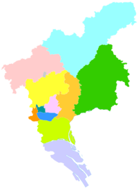 Nansha in Guangzhou | |
| Coordinates: 22°50′18″N 113°36′30″E / 22.83833°N 113.60833°E / 22.83833; 113.60833Coordinates: 22°50′18″N 113°36′30″E / 22.83833°N 113.60833°E / 22.83833; 113.60833 | |
| Country | People's Republic of China |
| Province | Guangdong |
| Sub-provincial city | Guangzhou |
| Area | |
| • Total | 803 km2 (310 sq mi) |
| Population (2012) | |
| • Total | 260,000 |
| • Density | 320/km2 (840/sq mi) |
| Time zone | UTC+8 (China Standard) |
| Area code(s) | 020 |
| Website | http://www.gzns.gov.cn/ |
| Nansha District | |||||||||||||||
| Simplified Chinese | 南沙区 | ||||||||||||||
|---|---|---|---|---|---|---|---|---|---|---|---|---|---|---|---|
| Traditional Chinese | 南沙區 | ||||||||||||||
Cantonese Yale | Nàahmsā Kēui | ||||||||||||||
| Hanyu Pinyin | Nánshā Qū | ||||||||||||||
| |||||||||||||||
| Alternative Chinese name | |||||||||||||||
| Chinese | 南沙 | ||||||||||||||
Cantonese Yale | Nàahmsā | ||||||||||||||
| Hanyu Pinyin | Nánshā | ||||||||||||||
| Literal meaning | south sands | ||||||||||||||
| |||||||||||||||

Nansha Sunflowers Garden
Nansha District, is a district of Guangzhou, China. It is the home of the present-day port of Guangzhou, as well as the Nansha Wetland Park.
The Nansha Technology Development Zone was carved out of Panyu District in 1993. In 2005 it was named Nansha District. In September 2012, Nansha was designated a State-level New Area as Nansha New Area the sixth such area.[1]
Contents
1 Administrative divisions
2 Transportation
2.1 Metro
3 References
4 External links
Administrative divisions
| Name | Chinese (S) | Hanyu Pinyin | Canton Romanization | Population (2010)[2] | Area (km2) |
|---|---|---|---|---|---|
| Nansha Subdistrict | 南沙街道 | Nánshā Jiēdào | nam4 sa1 gai1 dou6 | 112,151 | 57.80 |
| Zhujiang Subdistrict | 珠江街道 | Zhūjiāng Jiēdào | ju1 gong1 gai1 dou6 | 28,575 | 41.50 |
| Longxue Subdistrict | 龙穴街道 | Lóngxué Jiēdào | lung4 yud6 gai1 dou6 | 44,891 | 128.90 |
Wanqingsha Town | 万顷沙镇 | Wànqǐngshā Zhèn | man6 king2 sa1 zen3 | 319.20 | |
Huangge Town | 黄阁镇 | Huánggé Zhèn | wong4 gog3 zen3 | 43,791 | 76.50 |
Hengli Town | 横沥镇 | Hénglì Zhèn | wang4 lig6 zen3 | 30,492 | 54.00 |
Dongchong Town | 东涌镇 | Dōngchōng Zhèn | dung1 chung1 zen3 | 147,228 | 92.00 |
Dagang Town | 大岗镇 | Dàgǎng Zhèn | dai6 gong1 zen3 | 125,011 | 90.07 |
Lanhe Town | 榄核镇 | Lǎnhé Zhèn | lam5 hed6 zen3 | 73,078 | 74.48 |
Transportation
Metro
Nansha is currently served by one metro line operated by Guangzhou Metro:
Line 4 - Dongchong, Qingsheng, Huangge Auto Town, Huangge, Jiaomen, Jinzhou, Feishajiao, Guanglong, Dachong, Tangkeng, Nanheng, Nansha Passenger Port
References
^ China Daily Nansha New Area launched Updated: 2012-09-13 14:56 "China has mapped out a new State-level development zone in South China's Guangdong province, the Shanghai Securities News reported on Wednesday. As the country's sixth State-level New Area, the Nansha New Area is expected to get national support from a series of preferential policies and innovation reforms on tax policy, land management, financial innovation and industrial development. The other zones are in Shanghai, Tianjin and Chongqing, as well as Zhejiang and Gansu provinces."
^ shi, Guo wu yuan ren kou pu cha ban gong; council, Guo jia tong ji ju ren kou he jiu ye tong ji si bian = Tabulation on the 2010 population census of the people's republic of China by township / compiled by Population census office under the state; population, Department of; statistics, employment statistics national bureau of (2012). Zhongguo 2010 nian ren kou pu cha fen xiang, zhen, jie dao zi liao (Di 1 ban. ed.). Beijing Shi: Zhongguo tong ji chu ban she. ISBN 978-7-5037-6660-2..mw-parser-output cite.citation{font-style:inherit}.mw-parser-output q{quotes:"""""""'""'"}.mw-parser-output code.cs1-code{color:inherit;background:inherit;border:inherit;padding:inherit}.mw-parser-output .cs1-lock-free a{background:url("//upload.wikimedia.org/wikipedia/commons/thumb/6/65/Lock-green.svg/9px-Lock-green.svg.png")no-repeat;background-position:right .1em center}.mw-parser-output .cs1-lock-limited a,.mw-parser-output .cs1-lock-registration a{background:url("//upload.wikimedia.org/wikipedia/commons/thumb/d/d6/Lock-gray-alt-2.svg/9px-Lock-gray-alt-2.svg.png")no-repeat;background-position:right .1em center}.mw-parser-output .cs1-lock-subscription a{background:url("//upload.wikimedia.org/wikipedia/commons/thumb/a/aa/Lock-red-alt-2.svg/9px-Lock-red-alt-2.svg.png")no-repeat;background-position:right .1em center}.mw-parser-output .cs1-subscription,.mw-parser-output .cs1-registration{color:#555}.mw-parser-output .cs1-subscription span,.mw-parser-output .cs1-registration span{border-bottom:1px dotted;cursor:help}.mw-parser-output .cs1-hidden-error{display:none;font-size:100%}.mw-parser-output .cs1-visible-error{font-size:100%}.mw-parser-output .cs1-subscription,.mw-parser-output .cs1-registration,.mw-parser-output .cs1-format{font-size:95%}.mw-parser-output .cs1-kern-left,.mw-parser-output .cs1-kern-wl-left{padding-left:0.2em}.mw-parser-output .cs1-kern-right,.mw-parser-output .cs1-kern-wl-right{padding-right:0.2em}
External links
| Wikimedia Commons has media related to Nansha District. |
- Official website of Nansha District government
Guangzhou | ||
|---|---|---|
| Administrative divisions |
|    |
| Attractions |
| |
| Culture & demographics |
| |
| Higher Education |
| |
| History |
| |
| Sports venues |
| |
| Transport |
| |
County-level divisions of Guangdong Province | |||||||||||||||||||||||||||||||||||||||||||||||||||||||||||||||||
|---|---|---|---|---|---|---|---|---|---|---|---|---|---|---|---|---|---|---|---|---|---|---|---|---|---|---|---|---|---|---|---|---|---|---|---|---|---|---|---|---|---|---|---|---|---|---|---|---|---|---|---|---|---|---|---|---|---|---|---|---|---|---|---|---|---|
Guangzhou (capital) | |||||||||||||||||||||||||||||||||||||||||||||||||||||||||||||||||
| Sub-provincial cities |
| ||||||||||||||||||||||||||||||||||||||||||||||||||||||||||||||||
| Prefecture-level cities |
| ||||||||||||||||||||||||||||||||||||||||||||||||||||||||||||||||
| |||||||||||||||||||||||||||||||||||||||||||||||||||||||||||||||||
Pearl River Delta Metropolitan Region (Yuegang'ao Greater Bay Area) | ||
|---|---|---|
Pearl River Delta Economic Zone | ||
| Guangdong Province |
|  |
| Special administrative regions |
| |


