Dungarpur
Dungarpur | |
|---|---|
City | |
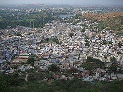 Aerial view of Dungarpur | |
 Dungarpur Location in Rajasthan, India Show map of Rajasthan  Dungarpur Dungarpur (India) Show map of India | |
| Coordinates: 23°50′N 73°43′E / 23.84°N 73.72°E / 23.84; 73.72Coordinates: 23°50′N 73°43′E / 23.84°N 73.72°E / 23.84; 73.72 | |
| Country | |
| State | Rajasthan |
| District | Dungarpur |
| Founded by | King Dungar Singh |
| Named for | Dungar singh |
| Government | |
| • Body | Dungarpur Munciple Council |
| Elevation | 225 m (738 ft) |
| Population (2011) | |
| • Total | 47,706 |
| Languages | |
| • Official | Hindi |
| • Spoken | Vagdi |
| Time zone | UTC+5:30 (IST) |
| Telephone code | 02964 ****** |
| Vehicle registration | RJ 12 |
| Sex ratio | 1:1 ♂/♀ |
| Website | dungarpur.rajasthan.gov.in |
Dungarpur is a city in the southernmost part of Rajasthan state of India. It is the administrative headquarters of Dungarpur District. It is the fastest developing town in extreme South Rajasthan with telshil Aspur . The rail line between Udaipur and Ahmedabad in Gujarat runs through the town, shortest distance to the National Highway 8 from Dungapur town is 20 km.It is the cleanest and first ODF(Open defecation free) free city in Rajasthan.
Contents
1 History
2 Climate
3 Places to see
4 Fairs and festivals
5 Demographics
6 Notable people
7 Notes
8 References
9 External links
History
Dungarpur is the seat of the elder branch of the Sisodiyas of Udaipur. The seat of the younger branch is that of the Maharana of Mewar. It was founded in 1358 A.D. by Rawal Veer Singh, the eldest son of the ruler of Mewar, Karan Singh[1] They are descendants of Bappa Rawal, eighth ruler of the Guhilot Dynasty and founder of the Mewar Dynasty (r. 734-753).
The chiefs of Dungarpur, who bear the title of Maharawal, are descended from Mahup, the eldest son of Karan Singh, a chief of Mewar in the 12th century, and claim the honours of the elder line of Mewar. Mahup, disinherited by his father, took refuge with his mother's family, the Chauhans of Bagar,[2] and made himself lord of that country at the expense of the Bhil chiefs.[3]While his younger brother Rahup founded a separate Sisodia dynasty[4][5]
The town of Dungarpur, the capital of the state, was founded towards the end of the 14th century by his descendant, Rawal Bir Singh, the Sixth descendant of Sawant Singh of Mewar, who named it after Dungaria, an independent Bhil chieftain whom he had ordered assassinated. After the death of Rawal Udai Singh of Bagar at the Battle of Khanwa in 1527, where he fought alongside Rana Sanga against Babar, his territories were divided into the states of Dungarpur and Banswara.[3] Successively under Mughal, Maratha, and British Raj control by treaty in 1818, it remained a 15-gun salute state[6]
In 1901 the total population of Dungarpur was 100,103, while that of the town was 6094. The last princely ruler of Dungarpur was HH Rai-i-Rayan Maharawal Shri Lakshman Singh Bahadur (1918–1989), who was awarded the KCSI (1935) and GCIE (1947), and after independence became a Member of the Rajya Sabha twice, in 1952 and 1958, and later a member of Rajasthan Legislative Assembly (MLA) in 1962 and 1989.[1]
Climate
The climate of Dungarpur is quite dry. The summer season is hot, but milder than most of the other Rajasthan cities. The average temperature in summers falls in the range of 43 °C (max) to 26 °C (min). Climatic conditions of Dungarpur, Rajasthan in winters are quite cool. The average temperature ranges between 25 °C (max) to 9 °C (min). Dungarpur weather experiences average rainfall hovering between 47 cm to 76 cm
Places to see
- Dev Somnath Mandir

Haveli Juna Mahal, Dungarpur
- Udai Bilas Palace
- Shree munisuvratnath digambar Jain Temple HATHAI
- Som Kamla Amba Dem
- Katkeshwar Mandir Katisour
- Shree Jetholeshwar Mahadev Temple, Oad
- Punali Hanuman temple. madiwala temple
- Juna Mahal or the Old Palace
- Shrinathji Temple
- Government Archaeological Museum
- District Library
- Shri Adinatha Jain Swetamber Temple
- Beneshwar Dham
- Rokadia Ganesh Temple
- Sarneshwar Mandir Temple
- Gap Sagar Lake
- shahid smarak park
- Naya Mahadev Temple
- RaghunathJi Temple Bhiluda
- Shree Nagariya Dada Ganpati Mandir (Bhiluda, Ganeshpury)
- Panch Mukhi Hanumanji Mandir & Kalyan Dham (Bhiluda Ganeshpury)
- Shree Mandaviya Hanumanji Mandir (Mandav)
- Shree Karadiya Hanumanji Mandir (Karada)
- Sita - Ram Ashram Jethana
- Siddhanath Mahadev Temple Thakarda
- Maa Bayan Temple - Ghatda (Ahada Ka Vada)
- Kali kalyan dham Temple - Ghatda
- Nana Bhai Park
- Fatehgadi
- Nagfunji Temple
- Hinglaj Mata Temple (Genji)
- Ganpati Temple (Punjpur)
- Lakshmi Narayan Temple (Punjpur)
- Shiv Mandir Punjela Talab (Punjpur)
- Bhagwati Mata Temple (Punjpur)
- Hanuman Temple (Punjpur)
- Jain Temple (Badouda)

Temple Dev Somnath
- Ratnagiri Mandir (Jain Temple|) Bankora
- Raja Mahal, Bankora
- Shree vishnu bhagwan mandir (samor sai) Khera samor
Fairs and festivals
- Baneshwar fair
Vagad festival,- mohd. damla qadri hussain festival
- Deevavo
- Amli Gyaras
- Vitthaldeo fair
- Urs Mubarak in Galiyakot (Syedi Fakhruddin Shaheed)
- ShreeShetrapaljidada fair Khadagada
- Very famous Purnima Garba [Bhiluda]
- Shree Jetholeshwar Mahadev Temple, Oad (Shivratri Mela)
- Siddhanath Mahadev Temple, Thakarda(Shivratri Mela)
- Stone pelting Holi [Bhiluda]
- Ram Navmi RagunathJi Temple[Bhiluda]
- Ram Navmi RagunathJi Temple[Nadia]
- Bhedmata Fair near Antri
- Shree Samor Sai Temple(Kherasamor)
- Jammu Khand Dhoni (Kathadi)
- Goreshvar Mahadev (Shivratri mela)
- Ratnagiri Mandir ( Jain Tample ) Bankora
- Old Mahal Bankora
- Jain Rathotsav Mela Paryushan Parv Peeth
Demographics
As of 2011[update]India census, Dungarpur had a population of 47,706. Males constitute 52% of the population a females 48%.[7] Dungarpur has an average literacy rate of 76%, higher than the national average of 59.5%: male literacy is 83% and, female literacy is 69%. In Dungarpur, 13% of the population is under 6 years of age
Notable people
Raj Singh Dungarpur, Cricketer, Administrator- Maharawal Shri Laxman Singh
Harshvardhan Singh Dungarpur, Rajya Sabha MP from Bharatiya Janata Party
- Dr. Nagendra Singh, President International Court of Justice
- Lt. General Nathu Singh Rathore
- Bhogilal Pandya
Notes
Dungarpur Rajya ka Itihasa (History: Kingdom of Dungarpur), by Gaurishankar Hirachand Ojha, First published 1936. Publisher: Rajasthani Granthaghar, Jodhpur 2000. .mw-parser-output cite.citation{font-style:inherit}.mw-parser-output .citation q{quotes:"""""""'""'"}.mw-parser-output .citation .cs1-lock-free a{background:url("//upload.wikimedia.org/wikipedia/commons/thumb/6/65/Lock-green.svg/9px-Lock-green.svg.png")no-repeat;background-position:right .1em center}.mw-parser-output .citation .cs1-lock-limited a,.mw-parser-output .citation .cs1-lock-registration a{background:url("//upload.wikimedia.org/wikipedia/commons/thumb/d/d6/Lock-gray-alt-2.svg/9px-Lock-gray-alt-2.svg.png")no-repeat;background-position:right .1em center}.mw-parser-output .citation .cs1-lock-subscription a{background:url("//upload.wikimedia.org/wikipedia/commons/thumb/a/aa/Lock-red-alt-2.svg/9px-Lock-red-alt-2.svg.png")no-repeat;background-position:right .1em center}.mw-parser-output .cs1-subscription,.mw-parser-output .cs1-registration{color:#555}.mw-parser-output .cs1-subscription span,.mw-parser-output .cs1-registration span{border-bottom:1px dotted;cursor:help}.mw-parser-output .cs1-ws-icon a{background:url("//upload.wikimedia.org/wikipedia/commons/thumb/4/4c/Wikisource-logo.svg/12px-Wikisource-logo.svg.png")no-repeat;background-position:right .1em center}.mw-parser-output code.cs1-code{color:inherit;background:inherit;border:inherit;padding:inherit}.mw-parser-output .cs1-hidden-error{display:none;font-size:100%}.mw-parser-output .cs1-visible-error{font-size:100%}.mw-parser-output .cs1-maint{display:none;color:#33aa33;margin-left:0.3em}.mw-parser-output .cs1-subscription,.mw-parser-output .cs1-registration,.mw-parser-output .cs1-format{font-size:95%}.mw-parser-output .cs1-kern-left,.mw-parser-output .cs1-kern-wl-left{padding-left:0.2em}.mw-parser-output .cs1-kern-right,.mw-parser-output .cs1-kern-wl-right{padding-right:0.2em}
ISBN 81-87720-01-8.
References
^ ab Dungarpur, History and Genealogy Archived 5 September 2011 at the Wayback Machine Queensland University.
^ Dungarpur State The Imperial Gazetteer of India, 1908, v. 11, p. 379.
^ ab One or more of the preceding sentences incorporates text from a publication now in the public domain: Chisholm, Hugh, ed. (1911). . Encyclopædia Britannica. 8 (11th ed.). Cambridge University Press. pp. 679–680.
^ D. C. Ganguly 1957, p. 91.
^
[1]Rajput,Eva Ulian,p.15.
^ Dungarpur, History and Genealogy RoyalArk
^ "Census of India 2011 - Dungarpur". Retrieved 15 Apr 2018.
External links
- Dungarpur's website
- Official website
- Dungarpur Guide
- Dungarpur District map (Invest Rajasthan)
- Dungarpur District News, Photos and Videos
State of Rajasthan | |||||||||||||||
|---|---|---|---|---|---|---|---|---|---|---|---|---|---|---|---|
Capital: Jaipur | |||||||||||||||
| Outline |
|  | |||||||||||||
| Governance |
| ||||||||||||||
Divisions and districts |
| ||||||||||||||
| Major cities |
| ||||||||||||||
| Related templates |
| ||||||||||||||


