Snow Valley Peak
| Snow Valley Peak | |
|---|---|
 | |
| Highest point | |
| Elevation | 9,218 ft (2,810 m) NAVD 88[1] |
| Prominence | 1,254 ft (382 m) [1] |
| Listing | Nevada County High Points 16th[1] |
| Coordinates | 39°09′14″N 119°52′59″W / 39.1537973°N 119.8829618°W / 39.1537973; -119.8829618Coordinates: 39°09′14″N 119°52′59″W / 39.1537973°N 119.8829618°W / 39.1537973; -119.8829618 [2] |
| Geography | |
 Snow Valley Peak | |
| Location | Carson City, Nevada, U.S. |
| Parent range | Carson Range |
| Topo map | USGS Marlette Lake |
| Climbing | |
| Easiest route | Tahoe Rim Trail |
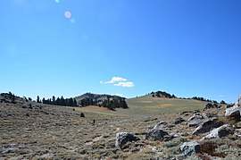
Snow Valley Peak is a mountain located in the Carson Range of the Sierra Nevada.[1] The mountain lies within the city limits of Carson City, NV. At 9,214 feet in elevation it is also the city's highest point.[1] From the peak Mound House, Carson City, Lake Tahoe, Reno and Carson Valley are all clearly visible. The peak is accessible along the Tahoe Rim Trail from the Spooner Lake Trailhead. The mountain is part of the Humboldt-Toiyabe National Forest although Lake Tahoe-Nevada State Park lies immediately to the west.[3]
The sources of three creeks begin on Snow Valley Peak: North Canyon Creek on the western flank, Clear Creek on the southern, and Ash Canyon Creek on the eastern.[4]
References
^ abcde "Snow Valley Peak". Peakbagger.com. Retrieved 2011-06-27..mw-parser-output cite.citation{font-style:inherit}.mw-parser-output q{quotes:"""""""'""'"}.mw-parser-output code.cs1-code{color:inherit;background:inherit;border:inherit;padding:inherit}.mw-parser-output .cs1-lock-free a{background:url("//upload.wikimedia.org/wikipedia/commons/thumb/6/65/Lock-green.svg/9px-Lock-green.svg.png")no-repeat;background-position:right .1em center}.mw-parser-output .cs1-lock-limited a,.mw-parser-output .cs1-lock-registration a{background:url("//upload.wikimedia.org/wikipedia/commons/thumb/d/d6/Lock-gray-alt-2.svg/9px-Lock-gray-alt-2.svg.png")no-repeat;background-position:right .1em center}.mw-parser-output .cs1-lock-subscription a{background:url("//upload.wikimedia.org/wikipedia/commons/thumb/a/aa/Lock-red-alt-2.svg/9px-Lock-red-alt-2.svg.png")no-repeat;background-position:right .1em center}.mw-parser-output .cs1-subscription,.mw-parser-output .cs1-registration{color:#555}.mw-parser-output .cs1-subscription span,.mw-parser-output .cs1-registration span{border-bottom:1px dotted;cursor:help}.mw-parser-output .cs1-hidden-error{display:none;font-size:100%}.mw-parser-output .cs1-visible-error{font-size:100%}.mw-parser-output .cs1-subscription,.mw-parser-output .cs1-registration,.mw-parser-output .cs1-format{font-size:95%}.mw-parser-output .cs1-kern-left,.mw-parser-output .cs1-kern-wl-left{padding-left:0.2em}.mw-parser-output .cs1-kern-right,.mw-parser-output .cs1-kern-wl-right{padding-right:0.2em}
^ "Snow Valley Peak". Geographic Names Information System. United States Geological Survey. Retrieved 2014-01-29.
^ "Marlette-Hobart Backcountry Map" (PDF). Nevada Division of State Parks. Retrieved 2011-06-27.
^ U.S. Geological Survey. National Hydrography Dataset high-resolution flowline data. The National Map, accessed September 4, 2016
This Nevada state location article is a stub. You can help Wikipedia by expanding it. |


