Oberwiesenthal
Oberwiesenthal | ||
|---|---|---|
 | ||
| ||
Location of Oberwiesenthal | ||
 Oberwiesenthal Show map of Germany  Oberwiesenthal Show map of Saxony | ||
| Coordinates: 50°25′9″N 12°58′15″E / 50.41917°N 12.97083°E / 50.41917; 12.97083Coordinates: 50°25′9″N 12°58′15″E / 50.41917°N 12.97083°E / 50.41917; 12.97083 | ||
| Country | Germany | |
| State | Saxony | |
| District | Erzgebirgskreis | |
| Government | ||
| • Mayor | Mirko Ernst | |
| Area | ||
| • Total | 39.98 km2 (15.44 sq mi) | |
| Elevation | 914 m (2,999 ft) | |
| Population (2017-12-31)[1] | ||
| • Total | 2,108 | |
| • Density | 53/km2 (140/sq mi) | |
| Time zone | CET/CEST (UTC+1/+2) | |
| Postal codes | 09484 | |
| Dialling codes | 037348 | |
| Vehicle registration | ERZ | |
| Website | www.oberwiesenthal.de | |

Oberwiesenthal is a town and a ski resort in the district of Erzgebirgskreis in Saxony in Germany. It is situated in the Ore Mountains, on the border with the Czech Republic, 19 km south of Annaberg-Buchholz, and 23 km northeast of Karlovy Vary. At 914 metres (2,999 ft), it is the highest town in Germany.[2] The Olympic and World Championships goldmedalist in ski jumping Jens Weißflog competed for SC Tractor Oberwiesenthal and Oberwiesenthaler SV.
Contents
1 Geography
1.1 Neighbouring municipalities
1.2 Subdivisions
2 History
2.1 Historical Population
3 Politics
3.1 Town council
3.2 Mayor
3.3 Twinnings
4 Culture and sights
4.1 Museum
4.2 Structures
4.3 Sport
5 Notable people
6 References
Geography
Oberwiesenthal lies in the county of Erzgebirgskreis, on the border with the Czech Republic that follows the course of the Pöhlbach stream as far as Bärenstein (10 km northeast). The highest elevation in the borough is the Fichtelberg (sometimes called the Großer Fichtelberg or Great Fichtelberg) which, at 1,215 m above NN, is the highest mountain in Saxony.
Other important mountains in the region around Oberwiesenthal are the:
Keilberg (Klínovec) (1,244 m above NN; the highest summit in the Ore Mountains)
Kleiner or Hinterer Fichtelberg (1,206 m above NN) ("Little or Farther Fichtelberg")
Eisenberg (1,029 m above NN)

Climatic diagram for the Fichtelberg near Oberwiesenthal
Neighbouring municipalities
On the Czech side is the municipality of Loučná pod Klínovcem (Böhmisch Wiesenthal) and, further west, is Boží Dar (Gottesgab). Adjacent municipalities in Germany are Bärenstein, Crottendorf, Sehmatal, Breitenbrunn/Erzgeb. and Raschau-Markersbach.
Subdivisions
- Oberwiesenthal
- Unterwiesenthal
- Hammerunterwiesenthal
- Rotes Vorwerk
- Neues Haus

View of Oberwiesenthal and the Fichtelberg from the opposite side of the border (the cemetery at Háj)

Winter's view from the Great Fichtelberg
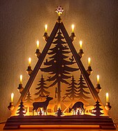
An Oberwiesenthal candle arch or Schwibbogen
History
The "new town in the Wiesen valley" ("Neustadt am Wiesenthal") was founded in 1527 by the lords of Schönburg as a mining town because, one year earlier, silver ore had been found in the region. By 1530 the new settlement had been granted town rights and, in 1559, its ownership passed to the House of Wettin.
Mining operations finally wound up in the 19th century and tourism increasingly took its place during the 20th. However, after the Second World War, there were attempts by the Russians to mine uranium for the nuclear arms race in the Zechengrund, today a nature reserve. Traces of their activity are still visible. On 1 September 1921 Oberwiesenthal was merged with the town of Unterwiesenthal further down the valley,[3] which had first been mentioned in the records in 1406 and had town rights by 1510.
Historical Population
|
|
|
|
Data source to 1990: Oberwiesenthal in the Digital Historic Index of Places in Saxony (Digitales Historisches Ortsverzeichnis von Sachsen)
Data source from 1998: Statistisches Landesamt Sachsen
Politics

Town hall (Rathaus)
Town council
The town council of Oberwiesenthal consists of 14 councillors and the directly elected mayor or Bürgermeister, who presides over the council. The local elections of 7 June 2009, which had a voter participlation of 62.5%, the following result:
| Party | FDP | CDU | BfW | Die Alternative | Die Linke | Total |
| Seats | 5 | 5 | 2 | 2 | 0 | 14 |
| Stimmenanteil | 35.1% | 33.4% | 13.5% | 12.6% | 5.4% |
Mayor
Heinz-Michael Kirsten (CDU) was elected mayor (Bürgermeister) in January 2002. By February 2002 the Annaberg district office (Landratsamt Annaberg) had declared this result void due to unpermitted election advertising. This resulted in a five-year legal battle by all sides that ended with a decision in 2007 by the Federal Administrative Court in Leipzig, that confirmed the decision in February 2007 by the administrative appeals tribunal (Oberverwaltungsgericht) of Bautzen as legal. Heinz-Michael Kirsten was then sent on leave by the regional authority (Regierungspräsidium). On 4 November 2007 a new election took place in which no party achieved an absolute majority. In the second round of elections on 18 November the independent (now FDP) candidate, Mirko Ernst, was elected mayor.
Twinnings
 Germany Fichtelberg, town "friendship" (Städtefreundschaft) since 3 October 1990
Germany Lauf an der Pegnitz, town friendship since 3 October 1990
Germany Schonach im Schwarzwald, town friendship since 3 October 1990
 Japan Hakuba, twin town since 18 August 2002
Culture and sights
- Fichtelberg Railway
Fichtelberg Cable Car (the oldest cable car in Germany)- Oberwiesenthal post coach in the style of the Deutsche Reichspost of 1939
Museum
- Ski and local history museum, Karlsbader Straße 3
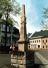
Electorate of Saxony postal milepost on the market square
Structures
St Martin Luther's Church with its Hertelt crib
Distance post on the market square (Marktplatz); whole milepost on the footpath to the "New House" (Neues Haus) in the Zechengrund and remnants of a half-milepost from the village of Hammerunterwiesenthal
- Royal Saxon station stone from the market square at the Neues Haus border crossing
Anton Günther Way, a cross-border trail
Sport
- Currently the leading sports club in the town: WSC Erzgebirge Oberwiesenthal
- Leading former East German Alpine and Nordic ski club, disbanded in 1990: SC Traktor Oberwiesenthal
Sportfördergruppe der Bundeswehr, armed forces sports centre
Notable people
Franz Ströher (1874-1936), German hairdresser and businessman

The Fichtelberg ski jumps
References
^ "Aktuelle Einwohnerzahlen nach Gemeinden 2017] (Einwohnerzahlen auf Grundlage des Zensus 2011)" (PDF). Statistisches Landesamt des Freistaates Sachsen (in German). October 2018..mw-parser-output cite.citation{font-style:inherit}.mw-parser-output q{quotes:"""""""'""'"}.mw-parser-output code.cs1-code{color:inherit;background:inherit;border:inherit;padding:inherit}.mw-parser-output .cs1-lock-free a{background:url("//upload.wikimedia.org/wikipedia/commons/thumb/6/65/Lock-green.svg/9px-Lock-green.svg.png")no-repeat;background-position:right .1em center}.mw-parser-output .cs1-lock-limited a,.mw-parser-output .cs1-lock-registration a{background:url("//upload.wikimedia.org/wikipedia/commons/thumb/d/d6/Lock-gray-alt-2.svg/9px-Lock-gray-alt-2.svg.png")no-repeat;background-position:right .1em center}.mw-parser-output .cs1-lock-subscription a{background:url("//upload.wikimedia.org/wikipedia/commons/thumb/a/aa/Lock-red-alt-2.svg/9px-Lock-red-alt-2.svg.png")no-repeat;background-position:right .1em center}.mw-parser-output .cs1-subscription,.mw-parser-output .cs1-registration{color:#555}.mw-parser-output .cs1-subscription span,.mw-parser-output .cs1-registration span{border-bottom:1px dotted;cursor:help}.mw-parser-output .cs1-hidden-error{display:none;font-size:100%}.mw-parser-output .cs1-visible-error{font-size:100%}.mw-parser-output .cs1-subscription,.mw-parser-output .cs1-registration,.mw-parser-output .cs1-format{font-size:95%}.mw-parser-output .cs1-kern-left,.mw-parser-output .cs1-kern-wl-left{padding-left:0.2em}.mw-parser-output .cs1-kern-right,.mw-parser-output .cs1-kern-wl-right{padding-right:0.2em}
^ Official web site (in German)
^ Das Sachsenbuch, Kommunal-Verlag Sachsen KG, Dresden, 1943, page 241
| Wikimedia Commons has media related to Oberwiesenthal. |
Towns and municipalities in Erzgebirgskreis | ||
|---|---|---|
| ||
Authority control |
|
|---|


