Dir District
Dir دیر | |
|---|---|
Natural region (former Princely state) | |
 | |
| Coordinates: 35°10′N 72°00′E / 35.167°N 72.000°E / 35.167; 72.000Coordinates: 35°10′N 72°00′E / 35.167°N 72.000°E / 35.167; 72.000 | |
| Country | |
| Area | |
| • Total | 5,282 km2 (2,039 sq mi) |
| Population (1998) | |
| • Total | 1,373,710 |
| • Density | 260/km2 (670/sq mi) |
| Languages | |
| • Spoken Language | Pashto |
| Time zone | PST |
| Largest city or town | Timergara and Dir town |
Dir is a region in northwestern Pakistan, in the Khyber Pakhtunkhwa. Lying in the foothills of the Himalayas it has beautiful valleys and scenic mountains. Before Pakistan was created, Dir was a princely state, and it remained so until 1969 when it was abolished by a presidential declaration,[1] with the Dir District being created the following year. Dir District was 5,280 square kilometres in area and lay along the disputed border controlled by the Afghan nationalists. The region is situated between Chitral and Peshawar. In 1996 the district was split into Lower Dir and Upper Dir.
It is bordered by:[2][3]
Chitral to the northwest and north
Swat to the east
Malakand to the south,
Bajaur Agency to the southwest,- and Afghanistan to the west.
Contents
1 Etymology and history
2 Demographics
3 Geography
4 Upper Dir
4.1 National Assembly
4.2 Provincial Assembly
5 Lower Dir
5.1 Tourist Places
5.2 National Assembly
5.3 Provincial Assembly
6 Administration
7 Notable people
8 Gallery
9 See also
10 Notes and references
11 External links
Etymology and history

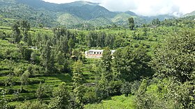
Lajbouk village
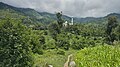
Dir derives its name from a Sanskrit word that means place of worship, monastery/convent where one can live in seclusion from others. The history of Dir goes back to at least the 2"d millennium BC, which is testified by the excavations of numerous burials of Aryans at Timargarha and other places, dating from 18th to 6th century BC. The Aryans were followed by the Achaemenians, who were ousted by the invasion of Alexander in 327 BC, though he faced great difficulties in subjugating the local population. Greek historians have paid great tributes to the population, the army and the queen of Massaga, an ancient site near the modern Ziarat village, located between Chakdara and Timergara. After the Greeks, the area witnessed the Gandharan Civilization, which achieved great fame. This period is signified by the presence of the monumental remains of the Buddhist stupas and monasteries, a few of which has already filled the museum at Chakdara.
The Yousafzai Pathans, who established themselves here in the 15th century AD, are responsible for the tribal, social, political and economic life of the region. Akhund lIyas Painda Khel of the Malizai tribe (1640) enjoyed popular support among locals and was recognized as a spiritual leader. His descendants built upon this support and ultimately increased their power over the people and laid the foundation of a distinct political state, then called the state of Nawabs. The British annexed Dir in 1897 and demarcated its boundaries. After independence of Pakistan, it still enjoyed the status of a separate state, but was amalgamated with Pakistan in 1960 as a tribal agency. It was finally merged as a district with the Khyber Pakhtunkhwa in 1969. In 1996 the decision was made to divide Dir District into two districts, Lower Dir and Upper Dir, with Timargarha and Dir as their respective headquarters, but, due to lack of funds, until 2000 they continued to be administered by a single district commissioner operating out of Timergara.

River panjkora flow through the region
Dir occupied an important position as a centre of Gandhara Art. Pilgrims and historians have defined Gandhara, (the land of fragrance and beauty), as "the area to the west of Indus and north of Kabul rivers which included the valleys of Peshawar, Swat, Dir and Bajaur, extending westwards to Hadda and Bamiyan in Afghanistan and Taxila Valley in Punjab in the east". The region of Dir is therefore littered with the remains of the Gandharan Civilization and the Dir Museum, Chakdara, offers a fine and unique collection of Gandharan Art.
Demographics

In Dir, 98% of the people are Pashtuns and Pashto is the main language.
The majority of the population in this area are Yousafzai, Mishwani, Tarran تاراڼ Tajak, Atrafi( اطرافي) Bahadur Shah Khel, Mast Khel, Khilji( Ghilji), Sahibzadgan, Miangan( Sadat ) and Roghani. The ruling class historically has been Yousafzai Pashtuns .
Kalami and Kohistani dialects are spoken in upper Dir. there is also another great known family known as shinwary who were live here from centuries and are the local rural of their place known as Munjai
Urdu is also widely spoken and understood.
Geography
Dir lies on the southeast side of the Hindu Kush and the major river is the Panjkora River which flows southwest through the region. The area covering survey sheets No: 38 M/12, 38 M/15, 38 M/16, 38 N/9 and 38 N/13 at 1:500000 scale. It is bounded by Chitral District on the North, Swat valley on the North-East, Afghanistan on the West, Lower Dir on the south and South-West.
Upper Dir
Upper Dir (Pashto: دیر بالا) is one of the 26[4] districts of Khyber Pakhtunkhwa. At the time of independence, Dir (princely state) was a state ruled by Nawab Shah Jehan Khan. It was merged with Pakistan in 1969 and later on declared as a district in 1970. In 1996, it was bifurcated into Upper and Lower Dir districts. This district is situated in the northern part of Pakistan. It borders Chitral district and Afghanistan on the north and north west and Swat district to the east, and on the south by Lower Dir District.[5]

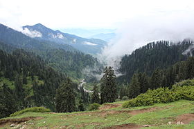
Kalkot Kumrat valley, Upper Dir
Except for Dir and a number of rapidly growing bazaar towns along the main roads, the population is rural, scattered in more than 1200 villages in the deep narrow valleys of the Panjkora and its tributaries.
Of these, notable villages are
- Khas Dir
- Barawal
- Gandigar
- Khall
- Darorra
- Ganori
- Shalkani
- Bibyawar
- Wari

The district is administratively subdivided into Tehsils which contain a total of 37 Union Councils:.[6] In lower dir there are two tehsils:
| Tehsil | Union councils |
|---|---|
| Timergara | ? |
| Jandool | ? |
| Adanzai |
National Assembly
This district is represented by one elected MNA (Member of National Assembly) in Pakistan National Assembly. Its constituency is NA-34.[7]
| Member of National Assembly | Party Affiliation | Year |
|---|---|---|
| Shahib Zada Muhammad Yaqub | Jamaat-e-Islami Pakistan | 2013 |
| Malak Azmat Khan | Pakistan Peoples Party | 2008 |
| Abdul Ghafoor Ghawas | Muttahida Majlis-e-Amal | 2003 |
| Qazi Hussain Ahmad | Muttahida Majlis-e-Amal | 2002 |
Qazi Hussain Ahmad won the general elections in 2002 but he left the seat as he had also won from his native constituency. Therefore, in January 2003 bye-elections were held.
Provincial Assembly
The district is represented by four elected MPAs in the provincial assembly who represent the following constituencies, after shifting of three union council from the Upper Dir to Lower Dir the provincial constituency of upper Dir, PF-93 now consists of UCs Khall, Toor Mang and Akha Gram of Lower Dir :[8]
PK-94 (Lower Dir-I) ( Inayat Ullah khan ).- PK-94 (Lower Dir-I)
- PK-95 (Lower Dir-II)
- PK-96 (Lower Dir-III)
- PK-97 (Lower Dir-IV)
Lower Dir
Lower Dir (Pashto: لر دیر ,Urdu: دیر زیریں) is one of the 26[4]districts in the Khyber Pakhtunkhwa province of Pakistan. The district was formed in 1996, when the district of Dir was divided into Upper Dir and Lower Dir. Timergara city is the district headquarters and largest city.[citation needed]
Dir District was officially split into Upper Dir and Lower Dir in 1996. Until 2000 as funds were not available to provide the accommodation needed at Dir town by government departments at a district headquarters, both districts continued to be administered by a single deputy Commissioner stationed at Timergara in Lower Dir.
Popular Tourists oriented Places[9]
- Temegara
- Talash
- Medan
- Koto, Haji Abad
- Jandol
- Adenzai
- Nowra
The place is located at a distance of 16 km from the Asbanr village and can be approached from this village in a four-wheel drive vehicle.
The district is administratively subdivided into Tehsils which contain a total of 37 Union Councils:.[6] In lower dir there are two tehsils:
| Tehsil | Union councils |
|---|---|
| Timergara | Timargara |
| Rabat |
Munaji
Jandool ||
Upper Dir District is 3,699 square kilometres in area and formed part of the former Malakand Division, lying along the Pakistan-Afghanistan border between Chitral, Bajaur Agency and Lower Dir.
It is connected with the Kohistan District via the Badawi Pass and connected with Chitral District through Lawari Pass and with Afghanistan through Bin Shahi Pass.
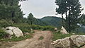
The topography of Upper Dir is dominated by high mountains. The most important mountain range is the Hind kush.[10] It runs from north east to south west along the northern borders with Chitral District. In winter whole area remains snow-covered. The mountains in the western part of the district are covered with forests, while the eastern mountain range, Dir Kohistan is barren. Panjkora River is the main river of the district, which originates from Dir Kohistan. Upper Dir headquarters is connected to all tehsil headquarters.[5]
Tourist Places

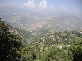
Laram top in winter lower Dir
In reality, the entire Dir region is a wonder of creation but to high authorities negligence and lack of communication roads, most of the areas are clouded in the mystery of infamy but still few areas which are recently developed includes;
Laram Top also known as "Laram Sar" is a scenic hill station in the Lower Dir District of Khyber Pakhtunkhwa, Pakistan at a distance of 30 km from Chakdara. It is located at elevation of 8500 ft above the sea level, surrounded by verdant mountains, towering trees and drenched in clouds. The Top receives heavy snow fall during winter season and attract a lot of tourists to its lap for a cool feeling in the sizzling heat of summer.
Jakar Baba Top is another hill station in the Lower Dir District of Khyber Pakhtunkhwa, Pakistan. It is encircled by pine trees.
Koherai bagh is another beautiful village in lower dir. People enjoy its beauty and also snow fall at the end of February of every year..
National Assembly
This district is represented by one elected MNA (Member of National Assembly) in Pakistan National Assembly. Its constituency is NA-34.[7]
| Member of National Assembly | Party Affiliation | Year |
|---|---|---|
| Shahib Zada Muhammad Yaqub | Jamaat-e-Islami Pakistan | 2013 |
| Malak Azmat Khan | Pakistan Peoples Party | 2008 |
| Abdul Ghafoor Ghawas | Muttahida Majlis-e-Amal | 2003 |
| Qazi Hussain Ahmad | Muttahida Majlis-e-Amal | 2002 |
Qazi Hussain Ahmad won the general elections in 2002 but he left the seat as he had also won from his native constituency. Therefore, in January 2003 bye-elections were held.
Provincial Assembly
The district is represented by four elected MPAs in the provincial assembly who represent the following constituencies, after shifting of three union council from the Upper Dir to Lower Dir the provincial constituency of upper Dir, PF-93 now consists of UCs Khall, Toor Mang and Akha Gram of Lower Dir :[8]
- PK-94 (Lower Dir-I)
- PK-95 (Lower Dir-II)
- PK-96 (Lower Dir-III)
- PK-97 (Lower Dir-IV)
Administration

The district is administratively subdivided into six tehsils which contain a total of 31-3=28 (3 UCs shifted to Lower Dir namely Khall, Akhagram and Toor Mang) Union Councils:[11]
| Name of Tehsil | No. of Unions |
|---|---|
Barawal | 3 |
Chapar | 3 |
Dir | 13 |
Kalkot | 3 |
Khal, Upper Dir | 4-3=1 (3 UC shifted to Lower Dir) |
Wari | 8 |
| Total | 31-3=28(3 UCs, shifted to Lower Dir) |
Upper Dir is represented in the National Assembly[12] and Provincial Assembly by one elected MNA and three elected MPAs respectively who represent the following constituencies:[13]
| Constituency | MPA | Party | ||||
|---|---|---|---|---|---|---|
| NA-33 (Upper Dir)[14] | Tariq Ullah | Jamat -e- Islami | ||||
| PF-91 (Upper Dir-I)[15] | Anayat ullah | Jamat -e- Islami | PF-92 (Upper Dir-II) | Muhammad Ali | Jamat -e- Islami | |
| PF-93 (Upper Dir-III)Cum Lower Dir (3 Union councils in Dir Lower) | vacant | ---- |
Notable people
Nawabzada Shahabuddin Khan, Khan of Jandool, (1933-1960) [16]
Inayat Ullah khan, Senior Minister KPK of Jamaat-e-Islami Pakistan, Health minister KPK ( 2002-2007 ), Ex-president Al Khidmat, Minister P&D KPK.
Siraj ul Haq, Emir of Jamaat-e-Islami Pakistan
Bakht Baidar, member of Khyber Pakhtunkhwa Assembly
ABDULLAH, president of Awami National Party Dubai, United Arab Emirates.
Gallery

See also
- Swat District
- Constituency NA-34
- Dir (princely state)
- Education in Lower Dir District
- Upper Dir District
- Timergara
Notes and references
^ "Upper Dir District: History of Dir". Syed Ziafat Ali. Archived from the original on 21 May 2015..mw-parser-output cite.citation{font-style:inherit}.mw-parser-output q{quotes:"""""""'""'"}.mw-parser-output code.cs1-code{color:inherit;background:inherit;border:inherit;padding:inherit}.mw-parser-output .cs1-lock-free a{background:url("//upload.wikimedia.org/wikipedia/commons/thumb/6/65/Lock-green.svg/9px-Lock-green.svg.png")no-repeat;background-position:right .1em center}.mw-parser-output .cs1-lock-limited a,.mw-parser-output .cs1-lock-registration a{background:url("//upload.wikimedia.org/wikipedia/commons/thumb/d/d6/Lock-gray-alt-2.svg/9px-Lock-gray-alt-2.svg.png")no-repeat;background-position:right .1em center}.mw-parser-output .cs1-lock-subscription a{background:url("//upload.wikimedia.org/wikipedia/commons/thumb/a/aa/Lock-red-alt-2.svg/9px-Lock-red-alt-2.svg.png")no-repeat;background-position:right .1em center}.mw-parser-output .cs1-subscription,.mw-parser-output .cs1-registration{color:#555}.mw-parser-output .cs1-subscription span,.mw-parser-output .cs1-registration span{border-bottom:1px dotted;cursor:help}.mw-parser-output .cs1-hidden-error{display:none;font-size:100%}.mw-parser-output .cs1-visible-error{font-size:100%}.mw-parser-output .cs1-subscription,.mw-parser-output .cs1-registration,.mw-parser-output .cs1-format{font-size:95%}.mw-parser-output .cs1-kern-left,.mw-parser-output .cs1-kern-wl-left{padding-left:0.2em}.mw-parser-output .cs1-kern-right,.mw-parser-output .cs1-kern-wl-right{padding-right:0.2em}
^ Schweitzer, Sylvia; et al. (2008). Islamic Republic of Pakistan, Dir Area Support Project, Completion Evaluation (Report No. 1993-PK) (PDF). Rome, Italy: International Fund for Agricultural Development (IFAD). p. 2. Archived (PDF) from the original on 6 December 2008.
^ "Vulnerable Areas and Threatening Water Channels - North Region". Provincial Disaster Management Authority, Government of Khyber Pakhtunkhwa. Archived from the original on 21 May 2015. Retrieved 6 November 2015.
^ ab Report, Bureau (16 January 2014). "KP govt creates new Kohistan district".
^ ab http://paiman.jsi.com/Resources/Docs/district-health-profile-upperdir.pdf
^ ab Tehsils & Unions in the District of Lower Dir - Government of Pakistan Archived 26 March 2012 at the Wayback Machine.
^ ab "Archived copy". Archived from the original on 10 November 2015. Retrieved 6 November 2015.CS1 maint: Archived copy as title (link)
^ ab Constituencies and MPAs - Website of the Provincial Assembly of the Khyber-Pakhtunkhwa Archived 28 April 2008 at the Wayback Machine.
^ http://www.pdma.gov.pk/documents/District_Tehsil_and_Union_code_Reference_Map_Upper_Dir.pdf[permanent dead link]
^ "Dir(Upper)". Welcome To Dir State The Land of Peace & Hospitality.
^ Zila, Tehsil & Town Councils Membership for NWFP - Government of Pakistan Archived 5 March 2009 at the Wayback Machine.
^ "Archived copy". Archived from the original on 17 February 2012. Retrieved 23 June 2012.CS1 maint: Archived copy as title (link)
^ Constituencies and MPAs - Website of the Provincial Assembly of the NWFP Archived 17 June 2009 at the Wayback Machine.
^ "Announced". Archived from the original on 17 June 2009. Retrieved 6 November 2015.
^ PF-91 (Upper Dir-I)Result: Announced Archived 15 November 2012 at the Wayback Machine.
^ (PDF) http://www.peshawarhighcourt.gov.pk/PHCCMS//judgments/R.F.A.--No.--53-M-of-2016--Govt-of-KPK-Vs--Nawabzada-M.-Shahabuddin.pdf. Missing or empty|title=(help)
External links
"Dir Map". Directorate of Information Technology, Government of Khyber Pakhtunkhwa. Archived from the original on 20 May 2015.
- Khyber-Pakhtunkhwa Government website section on Lower Dir
"Map of Lower Dir District" (PDF). UNICEF. Archived from the original (PDF) on 21 March 2012.
Places adjacent to Dir District | ||||||||||
|---|---|---|---|---|---|---|---|---|---|---|
| ||||||||||
Districts of Khyber Pakhtunkhwa | ||
|---|---|---|
Provincial capital: Peshawar | ||
| Divisions | Districts | 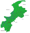 |
| Bannu |
| |
| Dera Ismail Khan |
| |
| Hazara |
| |
| Kohat |
| |
| Malakand |
| |
| Mardan |
| |
| Peshawar |
| |
Administrative divisions of Lower Dir District | ||
|---|---|---|
| Tehsils | Union Councils | |
| Adenzai |
| |
| Balambat |
| |
| Lal Qilla |
| |
| Munda |
| |
| Samar Bagh |
| |
| Timergara |
| |


