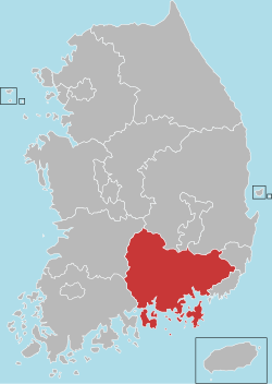
South Gyeongsang Province
South Gyeongsang Province .mw-parser-output .nobold{font-weight:normal} 경상남도 | ||
|---|---|---|
Province | ||
| Korean transcription(s) | ||
| • Hangul | 경상남도 | |
| • Hanja | 慶尙南道 | |
| • McCune‑Reischauer | Kyŏngsang-namdo | |
| • Revised Romanization | Gyeongsangnam-do | |
| ||
 | ||
Coordinates: 35°15′N 128°15′E / 35.250°N 128.250°E / 35.250; 128.250Coordinates: 35°15′N 128°15′E / 35.250°N 128.250°E / 35.250; 128.250 | ||
| Country | South Korea | |
| Region | Yeongnam | |
| Capital | Changwon | |
| Subdivisions | 8 cities; 10 counties | |
| Government | ||
| • Governor | Kim Kyoung-soo (Democratic) | |
| Area | ||
| • Total | 10,533 km2 (4,067 sq mi) | |
| Area rank | 4th | |
| Population (October, 2014) | ||
| • Total | 3,344,403 | |
| • Rank | 2nd | |
| • Density | 300/km2 (800/sq mi) | |
| Metropolitan Symbols | ||
| • Flower | Rose | |
| • Tree | Zelkova | |
| • Bird | White heron | |
| ISO 3166 code | KR-48 | |
| Dialect | Gyeongsang | |

South Gyeongsang Province (Korean: 경상남도, translit. Gyeongsangnam-do, Korean pronunciation: [kjʌŋ.saŋ.nam.do]) is a province in the southeast of South Korea. The provincial capital is at Changwon. It is adjacent to the major metropolitan center and port of Busan. There is UNESCO World Heritage Site Haeinsa, a Buddhist temple that houses the Tripitaka Koreana and attracts many tourists. Automobile and petrochemical factories are largely concentrated along the southern part of the province, extending from Ulsan through Busan, Changwon, and Jinju.
Contents
1 Etymology
2 History
3 Geography
4 Resources
5 Major cities
6 Attractions
7 Administrative divisions
8 Religion
9 Sister districts
10 See also
11 References
12 External links
Etymology
The name derives from Korean Gyeongsang, meaning 'joyous furthermore'; from gyeong (Korean 경, Hanja 慶), meaning 'happy', and sang (Korean 상, Hanja 尚), meaning 'still more'. The name derives from the names of the principal cities of Gyeongju (경주; 慶州) and Sangju (상주; 尙州).
History
Before 1895, the area corresponding to modern-day Gyeongsangnam-do was part of Gyeongsang Province, one of the Eight Provinces of Korea during the Joseon Dynasty. In 1895, southern Gyeongsang was replaced by the districts of Jinju in the west and Dongnae (modern-day Busan) in the east. In 1896, they were merged to form Gyeongsangnam-do.
The provincial capital was originally at Jinju; it moved in 1925 to Busan. In 1948, Gyeongsangnam-do became part of South Korea. In 1963, Busan separated from Gyeongsangnam-do to become a Directly Governed City (Jikhalsi). In 1983, the provincial capital moved from Busan to Changwon.
In 1995, Busan became a Metropolitan City (Gwangyeoksi), and Ulsan separated from Gyeongsangnam-do to become a Metropolitan City in 1997.
Geography
The province is part of the Yeongnam region, on the north by Gyeongsangbuk-do province, on the west Jeollabuk-do and Jeollanam-do provinces, and on the south by the Korea Strait far from Japan (Nagasaki Prefecture). Most of the province is drained by the Nakdong River and its tributaries. The total area of the province is 10,533 square kilometres (4,067 sq mi).[1]
Resources
The Nakdong delta plain around Gimhae is one of the best granaries in South Korea. Agricultural products form Gyeongsangnam-do include rice, beans, potatoes, and barley. The area is renowned for its cotton, sesame, and fruits which are grown along the southern seaside. A number of marine products are caught. The province is one of the country's leading fisheries.
Major cities
The largest cities in the region are Busan and Ulsan, which are separately administered as provincial-level Metropolitan Cities. Apart from the capital Changwon, other large or notable cities include Gimhae and Jinju.
Attractions
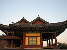
Yeongnamru in Miryang, province Gyeongsangnam-do. A pavilion from the Joseon Dynasty
Gyeongsangnam-do is the home of Haeinsa, a Buddhist temple that houses the Tripitaka Koreana and attracts many tourists. It is in the national park around Jirisan (1,915 m) on the border with Jeollabuk-do. The temple was first built in 802.
Changnyeong county contains three major tourist attractions for the province: Upo wetland, Bugok natural hotsprings, and Hwawang mountain.
Administrative divisions

Gimhae

Tongyeong

Yangsan
Gyeongsangnam-do is divided into 8 cities (si) and 10 counties (gun). The names below are given in English, hangul, and hanja.
| Map | # | Name | Hangul | Hanja | Population (2012)[2] | Subdivisions |
|---|---|---|---|---|---|---|
 | ||||||
— Specific City — | ||||||
| 1 | Changwon | 창원시 | 昌原市 | 1,106,081 | 5 ilban-gu — 2 eup, 6 myeon, 54 haengjeong-dong | |
| 2 | Gimhae | 김해시 | 金海市 | 531,383 | 1 eup, 6 myeon, 12 haengjeong-dong | |
— City — | ||||||
| 3 | Jinju | 진주시 | 晉州市 | 341,221 | 1 eup, 15 myeon, 15 haengjeong-dong | |
| 4 | Yangsan | 양산시 | 梁山市 | 274,770 | 1 eup, 4 myeon, 8 haengjeong-dong | |
| 5 | Geoje | 거제시 | 巨濟市 | 245,972 | 9 myeon, 10 haengjeong-dong | |
| 6 | Tongyeong | 통영시 | 統營市 | 143,039 | 1 eup, 6 myeon, 8 haengjeong-dong | |
| 7 | Sacheon | 사천시 | 泗川市 | 117,968 | 1 eup, 7 myeon, 6 haengjeong-dong | |
| 8 | Miryang | 밀양시 | 密陽市 | 109,967 | 2 eup, 9 myeon, 5 haengjeong-dong | |
— County — | ||||||
| 9 | Haman County | 함안군 | 咸安郡 | 70,443 | 2 eup, 8 myeon | |
| 10 | Geochang County | 거창군 | 居昌郡 | 63,536 | 1 eup, 11 myeon | |
| 11 | Changnyeong County | 창녕군 | 昌寧郡 | 64,297 | 2 eup, 12 myeon | |
| 12 | Goseong County | 고성군 | 固城郡 | 58,553 | 1 eup, 13 myeon | |
| 13 | Namhae County | 남해군 | 南海郡 | 48,899 | 1 eup, 9 myeon | |
| 14 | Hapcheon County | 합천군 | 陜川郡 | 50,713 | 1 eup, 16 myeon | |
| 15 | Hadong County | 하동군 | 河東郡 | 51,235 | 1 eup, 12 myeon | |
| 16 | Hamyang County | 함양군 | 咸陽郡 | 41,155 | 1 eup, 10 myeon | |
| 17 | Sancheong County | 산청군 | 山淸郡 | 36,079 | 1 eup, 10 myeon | |
| 18 | Uiryeong County | 의령군 | 宜寧郡 | 31,027 | 1 eup, 12 myeon | |
Religion
Religion in South Gyeongsang (2005)[3]
Not religious (45.2%)
Buddhism (40%)
Protestantism (8.8%)
Catholicism (6%)
According to the census of 2005, of the people of South Gyeongsang 40% follow Buddhism and 14.8% follow Christianity (8.8% Protestantism and 6% Catholicism).[3] 45.2% of the population is mostly not religious or follow Muism and other indigenous religions.
Sister districts
 Yamaguchi Prefecture (July 26, 1987)
 Maryland (November 18, 1991)
 Shandong (September 8, 1993)
 East Java (May 9, 1996)
 Đồng Nai Province (September 1, 1996)
 Khabarovsk Krai (September 14, 1996)
 Jalisco (March 10, 1997)
 Laguna province (April 15, 1997)
 Pomeranian Voivodeship (April 22, 1997)
 Fejér County (April 24, 1997)
See also
- List of Korea-related topics
Igeum-dong site - complex archaeological site in Sacheon-si- Tongyeong International Music Festival

Changnyeong Temple at the base of Mount Hwawang
References
^ 일반 현황 (in Korean). South Gyeongsang Province. Retrieved 18 March 2013..mw-parser-output cite.citation{font-style:inherit}.mw-parser-output q{quotes:"""""""'""'"}.mw-parser-output code.cs1-code{color:inherit;background:inherit;border:inherit;padding:inherit}.mw-parser-output .cs1-lock-free a{background:url("//upload.wikimedia.org/wikipedia/commons/thumb/6/65/Lock-green.svg/9px-Lock-green.svg.png")no-repeat;background-position:right .1em center}.mw-parser-output .cs1-lock-limited a,.mw-parser-output .cs1-lock-registration a{background:url("//upload.wikimedia.org/wikipedia/commons/thumb/d/d6/Lock-gray-alt-2.svg/9px-Lock-gray-alt-2.svg.png")no-repeat;background-position:right .1em center}.mw-parser-output .cs1-lock-subscription a{background:url("//upload.wikimedia.org/wikipedia/commons/thumb/a/aa/Lock-red-alt-2.svg/9px-Lock-red-alt-2.svg.png")no-repeat;background-position:right .1em center}.mw-parser-output .cs1-subscription,.mw-parser-output .cs1-registration{color:#555}.mw-parser-output .cs1-subscription span,.mw-parser-output .cs1-registration span{border-bottom:1px dotted;cursor:help}.mw-parser-output .cs1-hidden-error{display:none;font-size:100%}.mw-parser-output .cs1-visible-error{font-size:100%}.mw-parser-output .cs1-subscription,.mw-parser-output .cs1-registration,.mw-parser-output .cs1-format{font-size:95%}.mw-parser-output .cs1-kern-left,.mw-parser-output .cs1-kern-wl-left{padding-left:0.2em}.mw-parser-output .cs1-kern-right,.mw-parser-output .cs1-kern-wl-right{padding-right:0.2em}
^ "Population of Gyeongsangnam-do" (in Korean). Gyeongsangnam-do. Archived from the original on 2014-02-25. Retrieved 2013-07-16.
^ ab "2005 Census - Religion Results". Archived from the original on 2015-09-04.
External links
| Wikimedia Commons has media related to Gyeongsangnam-do. |
 South Gyeongsang travel guide from Wikivoyage
Official website (in English)
Places adjacent to South Gyeongsang Province | ||||||||||
|---|---|---|---|---|---|---|---|---|---|---|
| ||||||||||
South Gyeongsang | ||||||
|---|---|---|---|---|---|---|
Changwon (capital) | ||||||
 | Specific cities |
| ||||
| Cities |
| |||||
| Counties |
| |||||
| Regions |
|
|---|---|
| Provinces |
|
| Special autonomous province |
|
| Special city |
|
| Special autonomous city |
|
| Metropolitan cities |
|
| The Committee for the Five Northern Korean Provinces |
|
Authority control |
|
|---|


